10 Great Walks

A guide to Albany's spectacular walks for all ages!
Escaping our everyday life for a bushwalk in the natural environment can be an enjoyable and healthy pastime. However, the unique environment around Albany can also be challenging and subject to rapid weather changes. You need to be aware of the risks and take responsibility for your own safety and the safety of others in your group (especially children). Planning and preparing before your trip is a key component to staying safe and having an enjoyable experience.
The following are a few tips for planning your trip:
- Select a walk suitable to your fitness level and experience. All the walks on this map are graded to guide you using the Australian Walk Track grading system.
- Be prepared by taking clothing, water and equipment to suit changes in weather and track conditions.
- Walk with friends; it's more fun, and solo bushwalking creates its own risks.
- Let a reliable person know your plans before you go. Tell them where you are going and when you plan to return – be sure to advise them of your safe return.
- Carry a map and mobile phone, but please be aware that some areas around Albany do not have mobile phone coverage.
- Bushwalking is not recommended in hot and windy conditions due to the risk of bushfire.
Difficulty Levels
Easy
(Grade 1-2)

Grade One is suitable for the disabled with assistance, and Grade Two is suitable for families with young children.
Intermediate
(Grade 3)

Grade Three is recommended for people with some bushwalking experience.
Difficult
(Grade 4-5)

Grade Four is recommended for experienced bushwalkers, and Grade Five is recommended for very experienced bushwalkers.
Easy Walks (Grade 1-2)
Emu Point to Ellen Cove & Port Albany
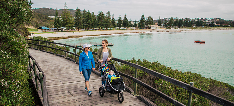
This is a versatile walk with many possible options which can be done in either direction.
The sealed path between Emu Point and Ellen Cove (4.6km) follows Binalup/ Middleton Beach with several access points to the beach and car parks and is relatively flat.
From Ellen Cove to Albany Port (3.5km), the path and boardwalk wind around the coast with stunning views. This section has rolling hills, while there are pathways leading down to rocky vantage points or up to lookouts.
This whole walk is on shared paths with cyclists, so please keep left.
|
Grade
Two (2)
Distance
8km one way
Gradient
Gentle hills
|
Quality of path
Well-formed path
Time
2 to 3 hours one-way
PDF Link
|
Tjuitgellong / Lake Seppings
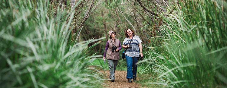
A tranquil walk through small groves of shady trees and alongside tranquil wetlands with stunning views of the lake and up to Mount Adelaide.
There are several lookouts, including a bird hide with interpretive signage and seats along the way.
It is a haven for waterbirds, with over 100 species known to visit this area, making it popular with birdwatchers. The lake is also a habitat for the western long-necked turtle, while Quenda are regularly seen on the trail.
A pleasant family walk that includes wheelchair access with assistance from the car park to some lookouts.
|
Grade
Two (2)
Distance
2.9km circuit
Gradient
Flat
|
Quality of track
Well-formed track
Time
45 minutes
PDF Link
|
Intermediate Walks (Grade 3)
Mount Clarence Heritage & Granite Trail

Mount Clarence, home of the Desert Mounted Corps Memorial, is part of the 260-hectare Albany Heritage Park in the heart of Albany.
The area offers a unique blend of natural, cultural and historical values and attractions with many interpretive signs allowing visitors to learn about the area.
The walk and features, including the Padre White lookout, provides breathtaking views of Mammang-Koort/ King George Sound, Princess Royal Harbour and as far as the Stirling Range.
A further option is to walk to the Padre White lookout following the well-signposted trail from the Town Square.
|
Grade
Three (3)
Distance
3.2km circuit
Gradient
Short, steep hills
|
Quality of path
Formed track, some obstacles
Time
1 to 2 hours
PDF Link
|
Mount Adelaide Nature Trail
Starting from the carpark at the corner of Forts Road and Apex Drive in Albany Heritage Park, this walk meanders through natural bushland with splendid views over Princess Royal Harbour, Mammang-Koort/ King George Sound and Binalup/ Middleton Bay from several vantage points.
The walk has many historical sites and interpretative signage regarding the area's military history found near the Heritage area, Forts and National ANZAC Centre.
King skinks are common on the trail, and wildflowers are plentiful in spring.
There are seats located throughout the walk and refreshments and toilets available near the National ANZAC Centre.
|
Grade
Three (3)
Distance
2.25km circuit
Gradient
Short, steep hills
|
Quality of track
Formed track, some obstacles
Time
45 minutes to 1 hour
PDF Link
|
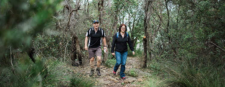
Luke Pen Kalgan River Walk
The Luke Pen Walk trail, located along the Kalgan River, is a beautiful meandering walk trail closely following the river.
The walk provides constantly changing views of the river and a mixture of vineyards, green pastures with grazing cattle and eucalypt bushland. The river is like a mirror on a calm day and provides amazing photography opportunities.
A shady walk for a hot day with opportunities to see the abundant wildlife that inhabits the river environment, including pelicans, ducks and osprey. While thornbills and both the Splendid and Red-winged Fairy-wrens can be seen in the bush beside the river.
|
Grade
Three (3)
Distance
12km return
Gradient
Gentle hills
|
Quality of track
Formed track, some obstacles
Time
3 to 4 hours
PDF Link
|
Uredale Point Heritage Trail
This is an excellent walk along the narrow isthmus between Princess Royal Harbor and Mammang Koort/ King George Sound from Whalers Cove with fabulous views of Princess Royal Harbour, Whalers Cove, Albany, and Mammang-Koort/ King George Sound.
The walk includes two sections of beach walking, steps up some steep sections and climbs over granite to the end of Uredale Point that provides views of the channel between Princess Royal Harbour and Mammang-Koort/ King George Sound which is the shipping access to Albany Port.
Wildflowers and whales abound in season, while dolphins are often seen in the bays and channels.
|
Grade
Three (3)
Distance
4.9km circuit
Gradient
Short, steep hills
|
Quality of track
Formed track, some obstacles
Time
2 to 3 hours
PDF Link
|
Albany Windfarm to Little Grove
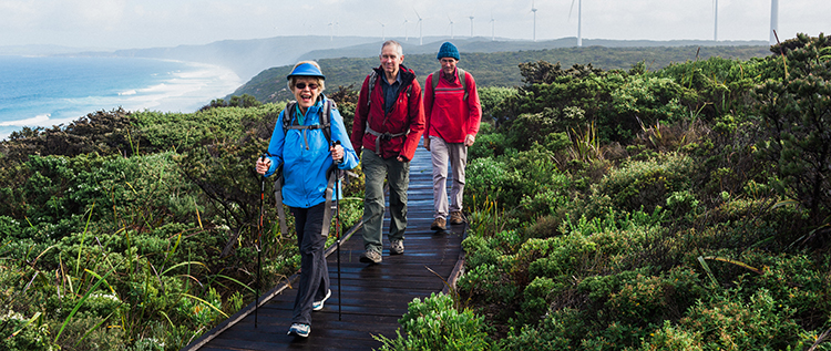
This walk forms part of the iconic Bibbulmun Track, which stretches from Kalamunda to Albany and is just over 1,000kms in length.
Starting at the Albany Windfarm with its 18 wind turbines, the track initially follows the path and boardwalk before it meanders over the sand dunes with many lookouts with views to Albany, Eclipse Island and Torbay to name a few.
The walk ends at the car park on the corner of Bay View Drive and Frenchman Bay Road.
Part of the walk is in the Torndirrup National Park where dogs are not allowed.
|
Grade
Three (3)
Distance
8.5km one way
Gradient
Short, steep hills
|
Quality of track
Formed track, some obstacles
Time
2 to 3 hours
PDF Link
|
Difficult walks (Grade 4 - 5)
Mount Martin Botanical Reserve
This walk in Gull Rock National Park is in a beautiful coastal setting and offers outstanding views of Breaksea and Michaelmas Islands, Albany's harbours, the Torndirrup Peninsula and inland to the Stirling Range.
The walk has several short, steep hills with steps. At its furthest point, Voyager Park, directly opposite Emu Point, provides a good picnic spot.
There is an extensive range of plant life, including orchids, Banksia, Dryandra. Kingia and more.
Good whale watching opportunities during the season
As the walk is in the national park, dogs are not allowed.
|
Grade
Four (4)
Distance
12.3km circuit
Gradient
Short, steep hills
|
Quality of path
Formed track, some obstacles
Time
4 to 5 hours
PDF Link
|
Peak Head Torndirrup National Park
Peak Head is the Torndirrup Peninsula's southernmost peak. It can be reached only via a rugged 4.3 km return walk track, steep in sections providing a challenging but rewarding experience.
Some rock scrambling is required to reach the peak's summit, and walkers must be aware of slippery rocks and that rock climbers may be on the cliffs below.
There are magnificent views of Eclipse Island, West Cape Howe, Bald Head and the vast Southern Ocean, where whales can be seen breaching between June and September.
The heathland along this walk comes alive in wildflower season.
|
Grade
Four (4)
Distance
4.3km
Gradient
Very steep
|
Quality of path
Formed track, some obstacles
Time
2 to 2.5 hours
PDF link
|
Bald Head Torndirrup National Park
The Bald Head Walking trail provides spectacular views of the striking coastal scenery of the Flinders Peninsula in Torndirrup National Park.
Walkers are rewarded with breathtaking views of the coastline along the trail and at the end of the track.
In several spots, the Southern Ocean to the south and Mammang-Koort/ King George Sound to the north can be seen from the same location as the trail follows the ridgeline providing spectacular photographic opportunities.
The trail winds over 8km through low heath until it reaches the cairn at Bald Head before walkers return along the same trail.
|
Grade
Four (4)
Distance
16km return
Gradient
Short, steep hills
|
Quality of path
Rough track, many obstacles
Time
6 to 7 hours
PDF link
|
Protect what we love!
Bushwalking in bushland areas has the potential to spread dieback. Dieback (Phytophthora cinnamomi) is a plant pathogen that is recognised as one of the key threatening processes to Australia's biodiversity.
Dieback lives in soil, water and plant material and attacks plant roots restricting the uptake of water and nutrients.
Human activity including bushwalkers causes the greatest spread of dieback. To help restrict the spread of dieback and protect the bushland that we love please;
- Clean your footwear before entering bushland areas.
- Use boot cleaning stations where available.
- Try to remove mud and soil when it is dry with a brush.
- Spray 70% methylated spirits on footwear.
For more information visit the Project Dieback website www.dieback.net.au