A diversity of ecosystems hosted in the shadow of regal forests, the exultation of granite peaks that emerge from the landscape, or sparkling turquoise bays studding protected stretches of unspoilt coastline.
Where will you choose to begin your adventure? See below for ideas to experience the National Parks of the Great Southern.
National park fees apply in the Great Southern, park passes can be purchased at Albany Visitor Centre
To assist in planning your visit, please see the website link below to check on National Park closures and alerts.
If you choose to hike in some of the Great Southern's more rugged locations, you will need to prepare well.
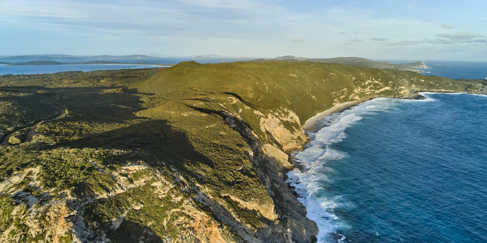
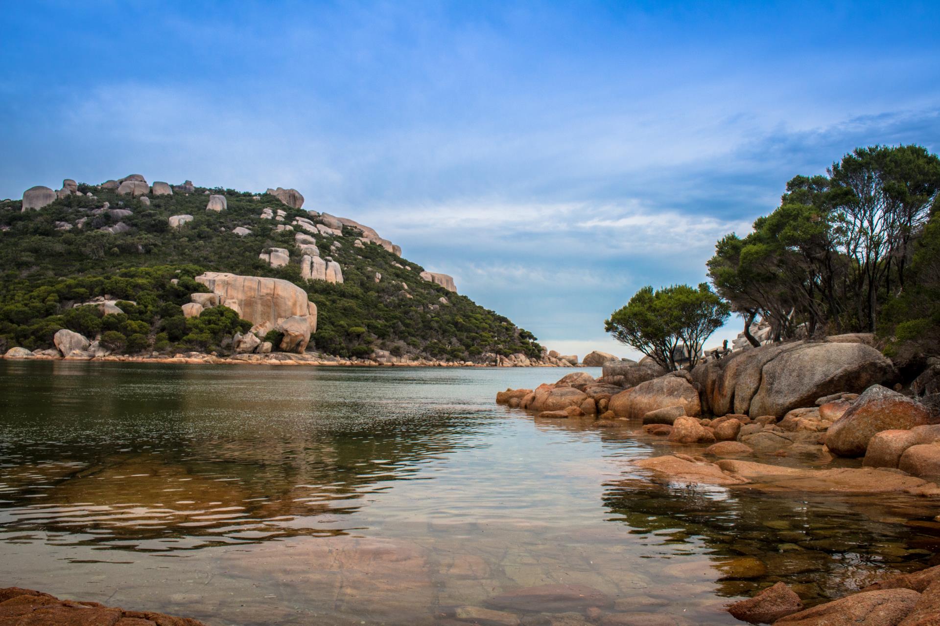
Torndirrup National Park
*Please note Cable Beach and access to the lighthouse are closed.
Click here to view full details of park closures.
| Distance from Albany |
10 kilometres south |
| Activities |
Fishing, Surfing, Bushwalking |
| Facilities |
Lookout |
Three connected peninsulas, Torndirrup, Vancouver and Flinders, embrace and protect Albany’s Princess Royal Harbour.
Torndirrup National Park occupies the rugged southern coastline of Torndirrup and Flinders peninsulas where limestone cliffs, granite headlands and white sandy beaches bear the full force of the powerful Southern Ocean. Located 10 kilometres south of Albany, this 3,906-hectare national park is one of the most visited in Western Australia. All park roads are suitable for two-wheel drive vehicles.
The park’s wind-pruned coastal heathlands put on a colourful display of wildflowers in spring. Thickets of banksia heath lie inland from the granite headlands, providing a year-round banquet for the park’s smallest marsupial, the honey possum.
A mixed forest of medium height karri and swamp yate lies south of the knobbly finger of Vancouver Peninsula. Peppermint woodlands can be found throughout the park. The bush abounds with wildlife, although many species are nocturnal, including the dunnart, mardo and quenda. The park provides a habitat for many reptile species. It is not unusual to find a carpet snake stretched across a road in the sun. However, poisonous snakes such as tiger snakes and dugites are also frequently seen. If a snake blocks your road or pathway, it is best to turn around and come back later.
Seabirds and numerous birds of prey can be seen in the sky above the park. Look for a kestrel, black-shouldered kite, whistling kite or Square-tailed kite hovering nearly motionless above the scrub. Keen-sighted bushwalkers will see many swift-moving honeyeaters, wrens, red-eared firetails and other birds that live in the heath.
Trails and lookouts
There are a number of stunning lookouts and walk trails in the park, including Sharp Point, Jimmy Newells, Stony Hill, Peak Head, Salmon Holes, and Bald Head or you can visit secluded Misery Beach, voted Australia's Number 1 Top Beach in Australia in 2022.
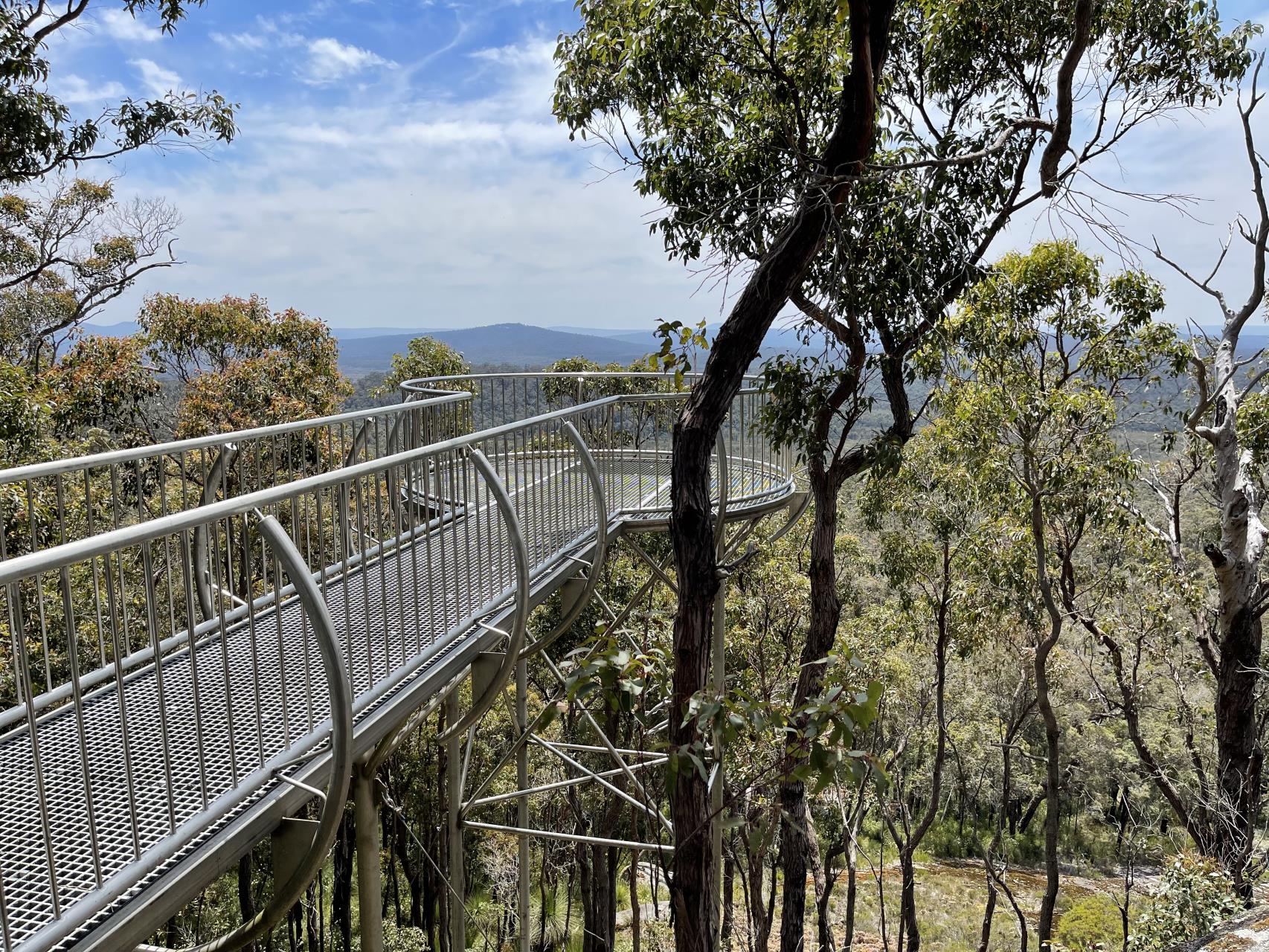
The Gap and Natural Bridge
A new universally accessible viewing platform at the Gap allows visitors to stand 40 metres directly above the surging seas, allowing those brave enough to view the true power of mother nature. The new raised pathways give safe access to stunning views and provide protection to vulnerable plants and lichens on the rock surface.
The pathway out to the Natural Bridge provides a stunning view of the bridge, a monumental span of granite demonstrating the awesome power of the sea when a heavy swell is running. Enjoy epic views of the Southern Ocean and the coast from Bald Head to West Cape Howe.
Gull Rock National Park
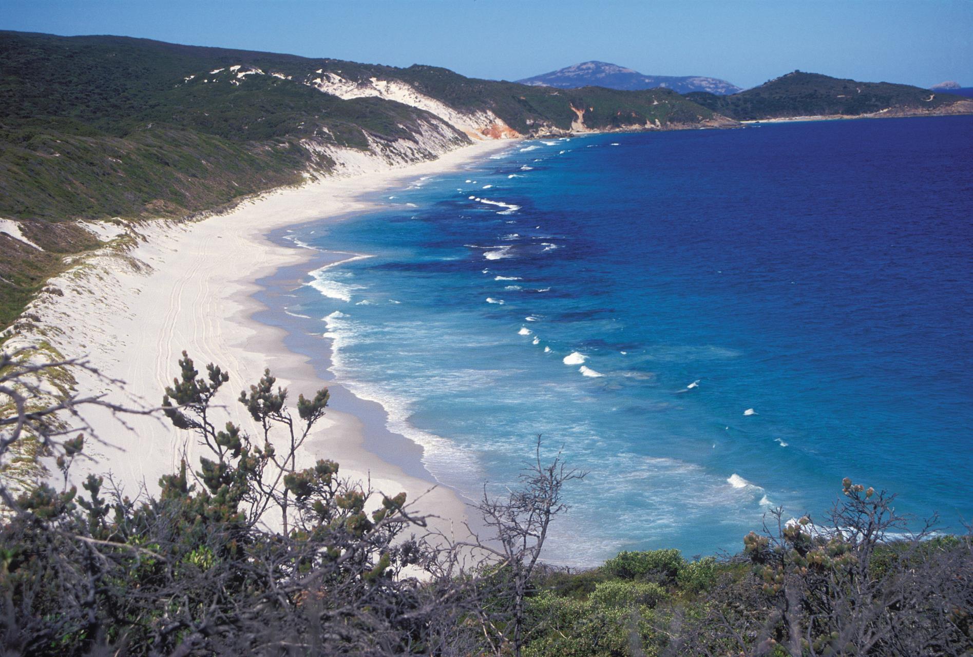
Photo by Tourism WA
| Distance from Albany |
25 kilometres east |
| Activities |
Diving, Horse riding, swimming, Surfing, Snorkelling, Fishing, Bushwalking |
Gull Rock National Park takes its name from a small island off Ledge Beach, which is in fact not part of the park. High vista points in the landscape offer outstanding views of Breaksea and Michaelmas Islands, Mammang-Koort/ King George Sound and Torndirrup Peninsula.
Gull Rock National Park is a day-use park popular with locals as a swimming beach over summer as it is protected from the prevailing south-easterly winds. Boiler Bay at the eastern end of Ledge Beach is the best area for swimming.
The park is well known for its bushwalking and the variety of wildflowers that can be found during Spring. Throughout its exceptional botanical richness.
West Cape Howe National Park
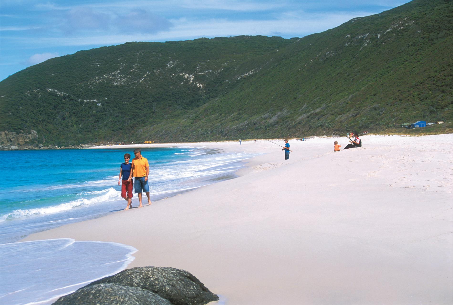
Photo by Tourism WA
| Distance from Albany |
30 kilometres west |
| Activities |
Hang gliding/ Paragliding, Fishing, Bushwalking, four-wheel driving |
| Facilities |
Toilet, Camping |
Jutting boldly into the Southern Ocean, West Cape Howe is the most southern promontory of Western Australia.
The park’s exceptionally scenic landscape includes dramatic cliffs of granite and black dolerite, isolated golden beaches, rock islands, rugged limestone outcrops and complex patterns of vegetation including patches of karri forest, peppermint thickets and windswept heathlands. Nearly 500 species of plants are found in the park including banksias, trigger plants and more than 50 species of orchids.
Swampy areas form a habitat for the carnivorous Albany pitcher plant and many bird species. Few facilities are provided in this wild area that lies about 30 kilometres west of Albany, yet it attracts campers, bushwalkers, fishermen plus fans of adventure activities.
Shelley Beach lookout is a prime launching site for hang-gliders. Two-wheel drive vehicles can reach Shelley Beach and the nearby lookout, but other sites within the park require a four-wheel drive. Park features can also be reached by bushwalking along the sandy four-wheel-drive tracks. Dolphins, seals and sea lions may be spotted from the coastal cliffs of either park. Humpback and southern right whales travel along the coastline during winter and early spring.
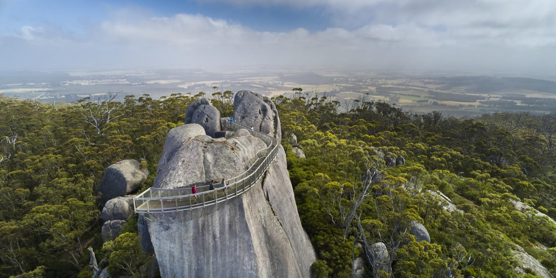
Porongurup National Park
| Distance from Albany |
40 kilometres North |
| Activities |
Bushwalking |
| Facilities |
Entry station, Toilet, Info shelter, BBQ, Lookout, |
Porongurup National Park features a 2600ha national park, home to over 750 native plant species. Spectacular views, great walks, dining options, wineries and a range of accommodation is available in the area; but no camping is permitted within the National Park.
- A challenging 4.7km return walk to Balancing Rock and the newly revamped Granite Skywalk provides amazing views. Starts at Castle Rock Picnic Area.
- The Granite Skywalk is a suspended walkway that spirals around the huge granite outcrop of Castle Rock to the summit. The upper skywalk lookout, one of two, perches over the side of Castle Rock and requires scrambling over rocks and climbing a ladder.
- Bolganup Heritage Trail is an easy 600m, 30min, Class 2 loop through Karri forest along a path that crosses a small creek.
- Devil’s Slide Trail is a challenging, 5km Class 4 return walk. Follow Wansbrough Walk for 1.6km, then turn to the right to reach a vantage point for magnificent views from the summit.
- Hayward Peak is a medium, 3km, 2hr return walk to Hayward Peak and back.
- Nancy Peak Walk is a steep, 5.5km, 2-3hr Class 4 circuit walk which heads up the northern side of the range and then along its spine, up and over Hayward Peak, Nancy Peak and Morgan’s View, before making its way back along the Wansbrough Walk.
- Wansbrough Walk is a 4km, one-way Class 4 walkthrough Karri forest along a gully between Nancy Peak and Devil’s Slide. The walk continues to the park’s southern boundary and connects with Millinup Road. Some visitors leave a vehicle at the southern end of the path and start at Tree-in-a-Rock.
Enjoy impressive views from a 23km scenic drive around the range via Bolganup Rd, Angwin Park Rd, Woodlands Rd, Millinup Rd, Chester Pass Rd and Mount Barker-Porongurup Rd.
There is also a 5km drive along Angwin Park Rd between Bolganup and Woodlands Rds, offering outstanding views of granite outcrops and Stirling Range to the north.
Mount Lindesay National Park
| Distance from Albany |
68 kilometres west |
| Activities |
Bushwalking |
| Facilities |
Picnic table, Info shelter, Toilet |
The focal point of Mount Lindesay National Park is the granite outcrop, home to threatened ecological communities. Some of the plants here are found nowhere else in the world!
A place like no other
Threatened ecological communities occur where the plants that exist in a few places only are isolated and vulnerable to threatening processes, such as climate change, unregulated recreation and dieback.
Scientists have examined plants across many regions and established that the jarrah scrub, mallee heath, scrub and herbs that grow in and around the granite outcrops at Mount Lindesay are distinct from other areas.
Year-round wildflowers
A fringe of jarrah and marri around the base of Mount Lindesay gives way to scrub growing on the shallow soil deposits gathered on the granite rock. This range of soils enables a range of magnificent wildflowers to grow. They are at their best in late spring however you are sure to find some plants in bloom at all times of the year.
A focal point for the district
Mount Lindesay has been a dominant landmark for Europeans since their first visit in 1829 in a party led by Dr Thomas Braidwood Wilson. Upon reaching the summit, he saw the highest peaks in the surrounding district. He named the peaks Mount Roe, Mount Mitchell and Mount Frankland after the Surveyor Generals of Australia.
Waychinicup National Park
| Distance from Albany |
69 kilometres east |
| Activities |
Fishing, Swimming, Camping, Wildflowers |
| Facilities |
Camping (fees apply), BBQ, Toilet |
Waychinicup National Park extends from Normans Beach and the Waychinicup River mouth to Cheynes Beach, not far from Albany. It has a scenic inlet, unusual granite rock formations and views both inland and along the coast.
Camping is permitted in the campground (camping fees apply), but space is limited and not suitable for caravans. Facilities are a gas barbecue and toilet. No fires are permitted. Accommodation is available at the privately operated Cheyne Beach Caravan Park just outside the park boundaries.
The coastal heath around Waychinicup is exceptionally diverse - possibly the most diverse in Western Australia - so in spring it is awash with colourful wildflowers. The name Waychinicup is derived from the Nyoongar word ‘waitch’, which means ‘emu’, and ‘up’, which means ‘place of’. The name first appeared on maps in 1877. The rough gravel entry road off Cheyne Beach Road is suitable for two-wheel drives but can become flooded. Please drive with caution as the road is narrow in places and has speed humps for water drainage along the last section towards the campground. When flooding occurs, access is only suitable for four-wheel drives.
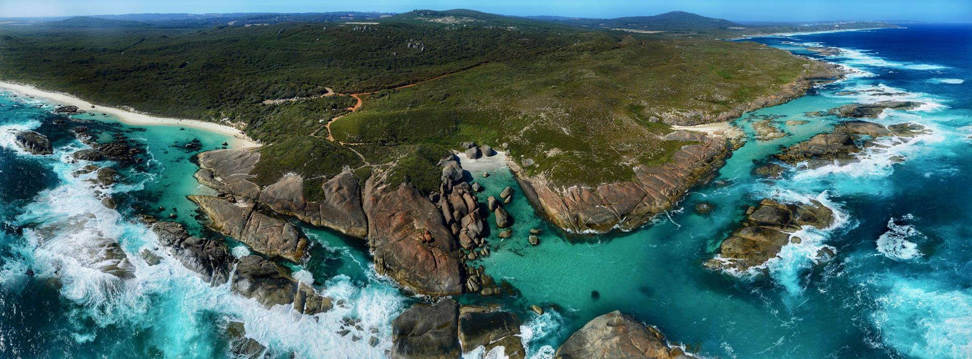
William Bay National Park
| Distance from Albany |
70 kilometres west |
| Activities |
Diving, Canoeing & Kayaking, Snorkelling, Swimming, Surfing, Fishing, Bushwalking |
| Facilities |
Toilet, Lookout |
From windswept headlands and large granite outcrops to sheltered bays and beaches, William Bay National Park has something for everyone. Famous for its turquoise green waters edged by huge granite boulders, Greens Pool is the centrepiece of William Bay National Park. It is a perfect place for swimming, snorkelling, relaxing or exploring the granite rocks.
Sheltered pools, channels, granite terraces, offshore islands, rock pools, and wild, windswept beaches provide many different habitats for marine life and birds. Shorebirds nest on the beaches, colourful fish inhabit the rock pools and whales and dolphins pass by further out to sea.
A characteristic feature of the national parks on the south coast such as William Bay is that wildflowers may be found at any time of the year. There is a peak of flowering in spring but even in the hottest weather, flowers can be found, especially in the concealed habitats under the karri trees or under the dense coastal shrubs. Keep a lookout for the many species of orchids that grow in the park.
Hooded Plovers and other shorebirds are sometimes seen on the beaches of William Bay National Park. Sit quietly and watch how each of the birds move and feed – they are all so very different. The presence of dogs on beaches deters birds from nesting. Help to ensure that shorebirds feel safe to nest by leaving your dogs at home.
There is a short walk trail between Greens Pool and Elephant Rocks. For those who want a longer walk, why not walk past Greens Pool to Mazzoletti Beach? This wild and windswept beach stretches from the rocks west of Greens Pool in a graceful curve to Parry’s Beach. The Bibbulmun Track passes through William Bay National Park.
Stirling Range National Park
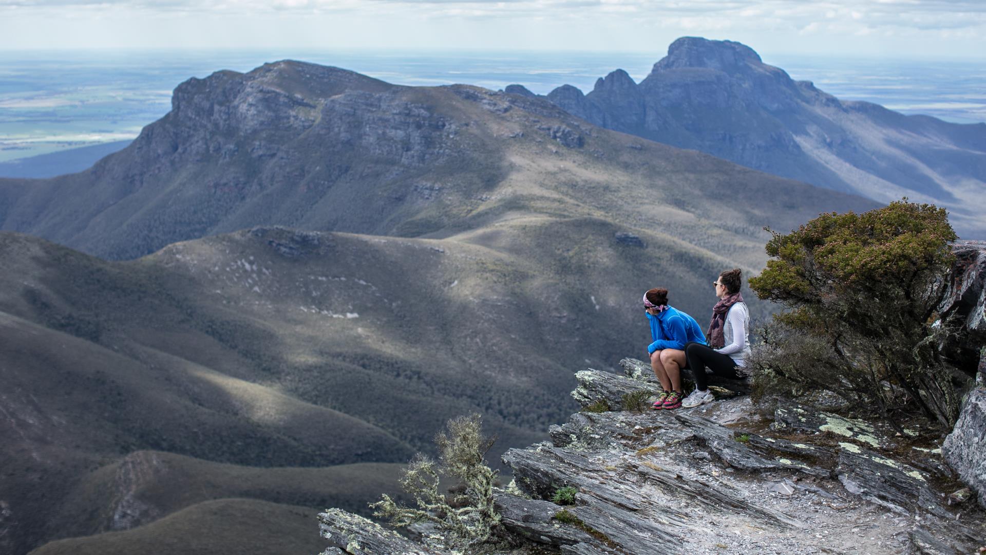
Photo by Tourism WA
| Distance from Albany |
100 kilometres northeast |
| Activities |
Bushwalking, Wildflowers |
| Facilities |
Toilet, Lookout, BBQ |
The Stirling Range National Park is named after the first Governor of WA, Captain James Stirling, the 115,671ha park has peaks rising more than 1000m above sea level. It’s particularly alluring for wildflower and bird enthusiasts, with over 1500 plants (82 endemic) and 140 bird species identified. There are many tracks providing easy access to wildlife and wildflowers. Bluff Knoll is the highest mountain in the range and the return walk from the base to the summit takes about 4hrs. A small national park entry fee applies per car to enter the drive to Bluff Knoll.
Stirling Range National Park is renowned for its unusual cloud formations. Its Aboriginal name, Koi Kyenunu-ruff, means ‘mist rolling around the mountains’ – a frequently seen occurrence. The range is also one of few places in WA where snow occasionally falls.
Scenic driving
The 42km Stirling Range Drive winds through the heart of the park on mostly unsealed roads graded for two-wheel drive. It stretches from the Western Lookout near Red Gum Spring to the Eastern Lookout below Bluff Knoll. Take a break in the drive to enjoy sweeping vistas from Central Lookout or a picnic in shady woodlands at White Gum Flat.
Mountain bushwalks
Walking is an ideal way to discover the rugged beauty and enchanting wildflowers of the Stirling Range, with established walks up Bluff Knoll, Mt Trio, Mt Toolbrunup, Mt Hassell, Talyuberlup Peak and Mt Magog. All are steep and have uneven surfaces.
The Ridge Walk is approximately 26km one way from the northeast corner of the park boundary via Ellen Peak to the Bluff Knoll Car park. This is a difficult and challenging, unmarked, cross country bushwalk of two to three days with no designated trail through a Wilderness Zone.
If you are considering undertaking the Stirling Range Ridge Walk, also known as the Eastern Peaks Ridge Route, or other cross-country walks, you are advised to contact the Stirling Range National Park rangers or the Albany District Office to obtain more detailed information. (Stirling Range National Park office – 9827 9230; Albany District office – 9842 4500).
Walpole-Nornalup National Park
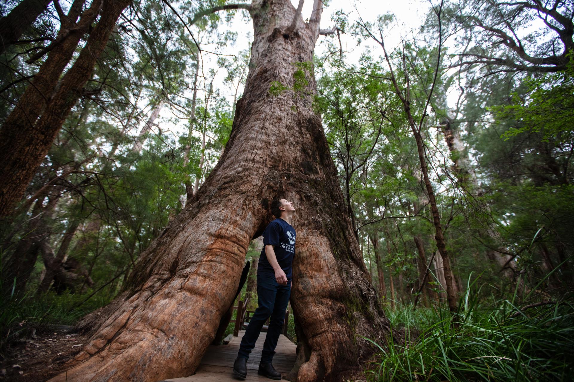
Photo by Tourism WA
| Distance from Albany |
120 kilometres west |
| Activities |
Canoeing & Kayaking, Swimming, Surfing, Bushwalking, Fishing |
| Facilities |
BBQ, Jetty, Visitor Centre, Boat ramp, Toilet, Lookout |
Located within the heart of the Walpole Wilderness is the tree-cloaked Walpole-Nornalup National Park, embracing rushing riverways, gnarled trees, rising mists and wild coast. It is home to tingle forests, which occur nowhere else in the world, and a patchwork of heathlands and wetlands, which occur closer to the coast.
The Valley of the Giants Tree Top Walk features a stunning walkway positioned 40 metres above the ground amid the dizzying heights of the tingle forest canopy. Experience walking in the Tree Top canopies of tall karri trees with views over core wilderness and then venture into the Ancient Empire of 400-year-old red tingle trees along a boardwalk that meanders across the forest floor. Purchase your Amazing South Coast pass here
The Hill Top Scenic Drive delivers you to magnificent views over the inlets at the Hilltop Lookout, then on to the Giant Tingle where you can walk your way through the towering forest at the Giant Tingle Tree. Venture on to Circular Pool for the raging river in winter, resulting in a swirling pool resembling a frothy coffee or a tranquil pool in summer.
View the whales on their migratory journey along the southern coastline from the lookout at Conspicuous Cliff and admire the beautiful coastal scenery all year round. A walker’s smorgasbord There are many bushwalking trails to discover this park, linking people with places. The Bibbulmun Track meanders through this park with short walks that spur off along the way at Mt. Clare.
Set out in a canoe to glide quietly over inlets and up the Deep and Frankland Rivers. Take a fishing line with you and catch a bream for your picnic lunch at Monastery Landing
Your safety
- Take care on rocks on the coast, as there is a risk of slipping and falling. Large waves can suddenly appear and wash over rocks.
- Don’t fish if it is too rough; know the weather forecast and tides before fishing. Always fish with someone else.
- Swimming at beaches and inland waterways can be dangerous. Be aware of strong rips, variable water depths, submerged obstacles and wet slippery surfaces. For your safety, do not dive or jump into the water.
- Restricted access and warning signs are placed there for your protection and safety, and to protect the environment.
- Stay alert and supervise children at all times.
Access
Walpole is just over 400km south of Perth, and the park lies east and west of Walpole. If travelling from Albany it is nearly 120 km to the west, allow one and a half hours for this scenic drive. - Department of Park and Wildlife,
Mount Frankland National Park
| Distance from Albany |
139 kilometres west |
| Activities |
Bushwalking |
| Facilities |
Picnic table, Toilet, BBQ, Lookout |
Dominated by an impressive granite peak, Mount Frankland National Park covers approximately 31,000 hectares of karri, jarrah and tingle forest and expanses of treeless heathland. From the top of Mount Frankland, enjoy 360-degree views of the Walpole Wilderness, home to many unique plants and animals.
History
Mount Frankland is one of three sites that make up the Walpole Wilderness Discovery Centre. Dr J Wilson named Mount Frankland after the then Surveyor-General of Tasmania after climbing Mount Lindesay during his explorations around Albany in 1829. The Aboriginal name for Mount Frankland is Caldyanup.
Mount Frankland walks
- The Towerman’s Hut is an easy walk to a gas barbecue and picnic area where you can explore the hut built in 1956. From here, the towerman left to climb to the summit of Mount Frankland several times a day to watch for fires and check the weather.
- View the Walpole Wilderness from high above the forest floor on the spectacular Wilderness View Lookout. From here it is a challenge to see any sign of human activity or habitation.
- Follow The Summit Trail to the towerman’s lookout on top of Mount Frankland. While the walk is strenuous, the views make it worthwhile – on a clear day you can see the Porongurup and Stirling ranges in the east and the Southern Ocean to the south. To get there you will need to climb a ladder and over 300 steep steps. Consider your fitness level and the weather conditions before proceeding. For more information visit TrailsWA.
- Take the trail to Soho Lookout and continue on the Caldyanup Trail. This trail loops around the granite bulk of Mount Frankland through the karri forest with views beyond.
Fitzgerald River National Park
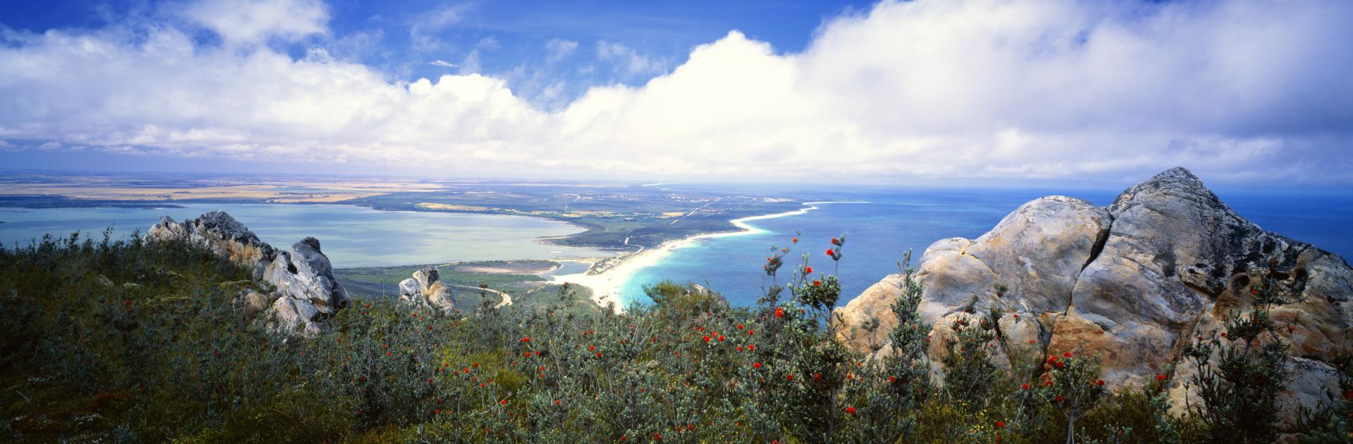
Photo by Tourism WA
| Distance from Albany |
180 kilometres northeast |
| Activities |
Canoeing & Kayaking, Surfing, Swimming, Snorkelling, Bushwalking, Fishing |
| Facilities |
Picnic table, Toilet, BBQ, Lookout, Boat ramp, Camping (fees apply) |
One of the largest and most botanically significant parks in Australia. The Fitzgerald River National Park features a tantalising variety of landscapes to explore from rolling plains, colourful breakaways, rugged peaks and headlands to stunning bays and inlets. During winter, southern right whales shelter close to shore at Point Ann with their newborn calves. From scenic drives to wonderful walks, camping, swimming, fishing and whale watching, the Fitz has it all!